Dunning is one of the 77 official community areas in Chicago, located on the Northwest Side. Wilbur Wright College, Mount Olive Cemetery, Zion Gardens Cemetery, and Eli’s Cheesecake Factory can all be found in this neighborhood.
In 1851, the prairie of Cook County was selected as the location for a poor farm, potter’s field, and asylum for the insane. Peter Ludby sold the 160-acre land, which was surrounded by Irving Park Road and Narragansett, Montrose, and Oak Park Avenues. A three-story building was constructed on a ridge to host both facilities. Families of the poor farm occupants lived on the grounds, growing vegetables, washing their clothes, and attending school. In 1863, the institution accepted tuberculosis patients. In 1870, a separate building was erected for the insane asylum, and two more buildings were added in the 1880s to be able to fit more than 1,000 patients.
After the Civil War, Andrew Dunning purchased 120 acres not far from the county property to establish a nursery and to lay down the basis for a village. He dedicated 40 acres for the purpose of the settlement, yet potential settlers were hesitant to move in due to its closeness to the insane hospital. Initially, the transportation connections were poor, but when the Chicago, Milwaukee & St. Paul Railway’s “crazy train” was extended to the area by a single track of three miles in 1882, it brought with it employees, commuters from the city, patients, supplies, and essential medicines. The county then constructed a station and named it after Dunning.
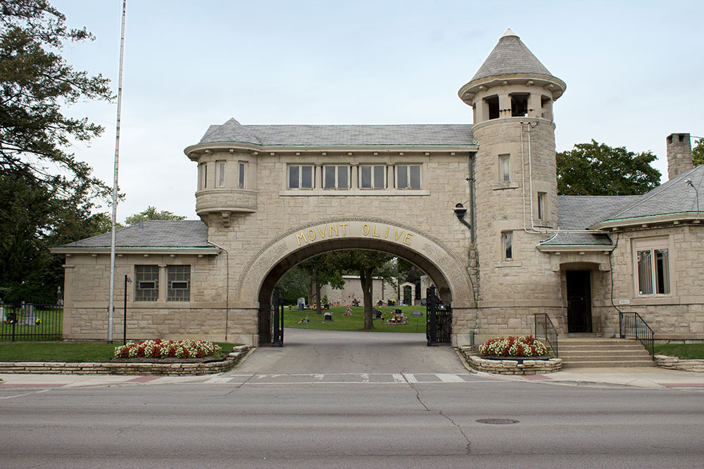
In the late 1800s, Dunning’s rolling topography was barely populated. In 1886, the Scandinavian Lutheran Cemetery Association bought 65 acres south of Dunning’s land, which then became known as the Mount Olive Cemetery. Jews then bought 40 acres between the Scandinavian cemetery and Addison for burials. At the dawn of the 20th century, Henry Kolze inherited a tavern and forested area at Narragansett and Irving Park, and he turned it into a picnic spot, known as Kolze’s Grove or Electric Park. This idyllic landscape attracted many visitors, as well as the tavern. With the arrival of the Irving Park Boulevard streetcar, clubs, churches and companies had picnics in the grove. The Chicago Department of Revenue’s records indicate that in 1910, other similar places such as Kosciuzko Grove were also located in the Dunning zone.
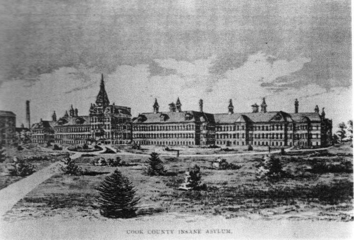
The infirmary, poorhouse, and asylum ended up becoming overstocked. Cold temperatures in the winter, no hot water, and inadequate ventilation all led to the demise of many patients and inmates. After an 1886 investigation, misconduct, wagering, patient mistreatment, and “influence” in the hiring of medical staff were all revealed. By 1910 the poor farm had been moved to Oak Forest, and two years later the state acquired the mental hospital and its property for a mere dollar. Even though it was known as the Chicago State Hospital, many people still referred to it as Dunning. In 1989, when work was being done close to Irving Park Rd. and Narragansett Ave., human remains were found. Research led to the rediscovery of Cook County Potter’s Field, which was located near the poor house and insane asylum. Approximately 38,000 individuals were buried there between the 1850s and 1920s. In 2002, a small park was created in their honor called the Read Dunning Memorial Park.
In 1909, the population outside the state facility amounted to only 1,305 people. By 1916, the first housing boom took place when Schorsch Brothers Real Estate purchased a tract just west of Austin and south of Irving Park, and named the area West Portage Park to diminish any link to Dunning. During the aftermath of World War I, the population increased to 4,019, with most of the people being of Swedish, German, or Polish origin. In 1934, Wright Junior College was built in the eastern section. At its apex in 1970, the population had risen to 43,856, however, by 1990, it had dropped to 36,957. The state hospital was in a state of disarray, and in the 1970s, close to half of the buildings were demolished. That same year, the Chicago-Read Mental Health Center was established, incorporating the former hospitals.
The village of Dunning is bordered by Harwood Heights, Norridge, River Grove, and Elmwood Park. The majority of its population is employed as city workers, such as police officers and firefighters. It also has proximity to the Harlem Irving Plaza shopping center. Institutional, commercial, and residential growth began to be seen in the 1980s and 1990s, with communities such as Schorsch Village, Belmont Heights, Belmont Terrace, and Irving Woods becoming more desirable. There are also luxury homes at Ridgemoor Estates, with a golf club nearby. The Chicago-Read Mental Health Center and the Wright Junior College have been updated with modern facilities, and the college also has a learning resource center. According to the 2010 U.S. Census, the population in Dunning had increased to 42,164 by 2000, and one in every three people living there is of Polish descent.